** Important Notice **
Refer to the email sent to runners on November 5, 2025, with the subject “HURT 100 Important Announcements”
The alternate course maps can be accessed below.
HURT100 Alternate Course Map
Multiple formats are available as discussed below. However, remember that all these maps are for general reference only. The errors in GPS measurements in the map and from your device in the mountains are often larger than the distance to a cliff edge or other hazard. Thus, while very useful to ensure you still on the race route and going in the right direction, you must constantly look out for trail hazards.
Printable Maps
- We recommend you print out the map and carry it with you.
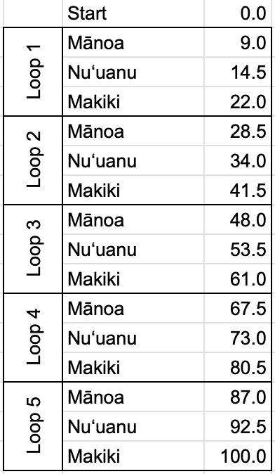
Checkpoint Chart

Geo-referenced PDF
- This is highly recommended for those not very familiar with the course!
- Detailed directions below.
- While it takes a few minutes to set up with a free app with your smart phone, using these will allow you to see your current location in relation to the course map in real-time. If set up ahead of time, this functionality is available while offline or in airplane mode (to save battery).
GPX
- This format is for those who desire a GPX file for their smartwatches.
- Click the following buttons for the GPX files:
Google maps – This is still original course
- Click here to show the course in Google maps.
- However, this will not be available offline and cell coverage along the course is spotty so we do not recommend relying on this while on the course.
How to download the alternate HURT race map to your phone (Geo-referenced PDFs)
1. Install the Avenza app to your smartphone.

Download the free Avenza Maps app from these app stores
Notes:
1) Free version is sufficient.
2) These maps also work in Gaia GPS or other apps if you have another favorite
2. Download map into Avenza Maps app.
- Open the app and create a free account if required
- Tap on the plus [+] icon in the top right side of screen
- Select “Import Maps”
- Select “From the Web” and then type or copy/paste the website address and tap “go”
- https://hurt100.com/HURT100-2026-Alt-Map.pdf
- If you get a message “This file appears invalid …” click Download (not Cancel) and it should work. If the file does not load, let us know
- You will then see it appear in your list of maps
- Tap on the map name to ensure it opens
Important notes:
- After you have followed these steps and see the map in the Avenza Maps app on your phone, on race day (or anytime you are actually on the map) you will be able to see your real-time location by simply opening the map. The GPS location arrow in the bottom left will center the map on your current location.
- It only requires GPS (not cell coverage) and will work in airplane mode if you are trying to save battery.
- For those that want to see it working prior to race day:
- If you are not on the course, you will not see your location. If you want to have a map where you will see your real-time location (i.e. the blue dot) to get a feel for the app, you can use this map of all of Oahu: https://caltopo.com/p/F08HC Download this map using the same instructions above and as long as you are on Oahu, you will see where you are.


